The Philippines does not ask permission — and does not need permission — to operate within its own exclusive economic zone.
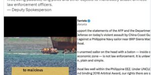
Let us be clear about the facts and the law: 1. Ayungin Shoal is a low-tide elevation within the Philippine exclusive economic zone and continental shelf. The 2016 Arbitral Award, …