Xiang Yang Hong 33 belongs to a class of Chinese oceanographic research ships operated under the State Oceanic Administration/Ministry of Natural Resources. While officially classified as scientific, vessels in this family routinely collect data with clear dual-use value: bathymetry, water column profiles, acoustic propagation characteristics, and seabed composition — all directly relevant to submarine operations and anti-submarine warfare.
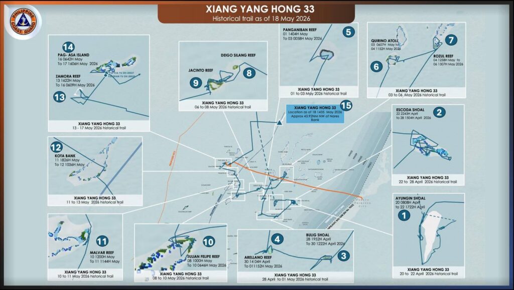
The track shows a deliberate, methodical sweep rather than a transit. Over roughly four weeks, the vessel touched at least 14 distinct features inside the Philippines’ Exclusive Economic Zone and the contested Spratlys before ending up northwest of Nares Bank.
The progression tells a story. It began on 20–22 April at Ayungin (Second Thomas) Shoal — the site of the BRP Sierra Madre and the most politically charged flashpoint in the area. From there it worked Escoda (Sabina) Shoal, another recent Chinese pressure point, then swept through Bulig and Arellano before moving up the western Spratlys: Panganiban (Mischief), Quirino (Jackson) Atoll, Rozul (Iroquois), Jacinto, Deigo Silang, Julian Felipe (Whitsun), Malvar, Kota Bank, Zamora (Subi), and Pag-asa (Thitu) — the largest Philippine-occupied island.
The vessel lingered in the Zamora–Pag-asa area from 13 to 17 May, with the Pag-asa segment itself running 16 May 0642H through 17 May 1606H. During that stay, two Chinese fishing/militia vessels (Yue Xia Yu 20027 and Yuezhan Yu 20020) are noted in close proximity — a telling co-location at the largest Philippine-occupied feature in the Spratlys.
Notably, Xiang Yang Hong 33 departed Pag-asa on the afternoon of 17 May — the same window in which the PCG conducted a MDA flight over the area. The timing is not coincidental. The vessel’s current fix at point 15 — 18 May 1435H, approximately 43.92 NM northwest of Nares Bank — confirms a now-recurring pattern: each time the PCG challenges it, whether by surface asset or aerial overflight, the illegal Marine Scientific Research (MSR) activity is halted and the vessel relocates.
The route hits every major Philippine-occupied or Philippine-claimed feature in sequence — Ayungin, Escoda, Pag-asa, Julian Felipe — features where Manila and Beijing have clashed in the past 18 months. The track itself is a statement of presence inside the EEZ.
The dense loitering patterns at specific reefs (the tangled tracks at Escoda, Julian Felipe, and Pag-asa) are consistent with detailed hydrographic and bathymetric survey work — multibeam mapping, sound velocity profiling, possibly deployment of expendable bathythermographs. This kind of data feeds directly into submarine navigation charts and ASW models for the South China Sea basin, which Chinese forces would need in any contingency involving the Bashi Channel or approaches to Palawan.
The co-location with maritime militia vessels at Pag-asa suggests coordination with the broader gray-zone presence rather than independent scientific work.
This deployment fits a now-familiar Chinese template: a research vessel conducts persistent, methodical MSR across contested waters under scientific cover, while militia and Coast Guard assets handle the visible pressure. What the 17 May departure demonstrates is that the template is not impervious — sustained Philippine presence, particularly aerial MDA, has a measurable disruptive effect. Each challenge forces the vessel to break station, abandon its survey grid, and reposition, degrading the continuity and quality of the data it can collect. Today’s track from Pag-asa to Nares Bank is the latest confirmation of that dynamic.
The fact that PCG is publishing a near-real-time historical trail is itself part of the contest: transparency as a counter to gray-zone ambiguity, and a public record that every Chinese MSR leg inside the Philippine EEZ has been observed, challenged, and interrupted.